Monday, September 21, 2015

September 3, Canada, Day 2


Just a few kilometers from Lake Louise is Moraine Lake. Sunrise at Moraine Lake was another of those memories from Elaine's first trip to the Rockies that we needed to revisit. We headed out in the crisp - okay, cold - predawn light to reach the lake before sunrise. By the time we got there, five other photographers were already there, set up, waiting for the sun. The weather stayed mostly broken clouds and the other photographers were disappointed. For me it was a magical time. I got some of the best photos of the trip. It was hard to decide which photo to post here. I uploaded a number of them to Flickr already so you can see more of this magical morning there.


Like I said, cold.


Eventually the sun did come out and the tour buses started arriving at Moraine Lake so we snuck back up the road for an early morning glimpse of Lake Louise.


From Lake Louise we headed back down the Bow River Parkway toward Banff to Johnston Canyon.

Johnston Canyon is one of the most popular day-hikes in Banff National Park. Johnston Creek starts in a glacial valley at 2,500 meters (8,200 feet). From there it cuts through the limestone rock before it empties into the Bow River 1,060 meters (3,480 feet) lower. Geologists estimate the water and rocks and ice have been grinding away at the canyon for 8,000 years. That makes it the same age as our reef at Shacks Beach.
  

There are two aptly-named water falls in the canyon: Lower Falls


and Upper Falls


In between there is a small waterfall that could have named Small Fall or, in keeping with the existing naming system , Middle Falls. Alas, this smaller drop remains nameless.


Johnston Canyon was one of the first places (after the improvements to the roads) where Elaine noticed - and to some degree bemoaned - the "civilization" of the area.


There are now handrails and gravel trails where years ago the trails were rugged and barely marked. As we talked through the changes, they became more acceptable. First, people are going to walk to beautiful places like this. Providing paths actually helps protect the sensitive environments.Second. the paths and handrails make it possible for more people of more fitness and mobility levels to enjoy this beauty.I'm sure that at some times of year these trails are nearly overrun with visitors but for us it was amazingly peaceful.

This is also where I learned (or relearned, actually) to always look around the next curve: something amazing is going to be there!


Friday, September 18, 2015

Septwmber 2, Canada, Day 1

Aguadilla to Newark, Newark to Calgary, Alberta

Greeted by this massive wild horse sculpture in the Calgary airport. Not a bad start.


On Hwy 1, the Trans-Canada Highway, we saw some great hay in the fields. We later learned that Alberta, in fact all of western Canada has been under a drought. Hay is very hard to get and very expensive.


My first views of the Canadian Rockies on the road to Banff.


There will be many more mountain pictures, I promise.

And on to Lake Louise


Getting b=Elaine back to Lake Louise and Moraine Lake (among other places) was one of the reasons for this trip. She backpacked through here when she was in college and has wanted to come back ever since. I am beginning to understand why!

Our first night in Deer Lodge


Deer Lodge is owned by Canadian Rockie Mountain Resorts (CRMR). They own properties all through Western Canada. They tend to be pricey but they are all very nice.

Thursday, September 10, 2015

Two days on a train


The biggest single thing in our trip to the Canadian Rockies was two days on the Rocky Mountaineer's "Journey Through the Clouds."


We boarded the train in Jasper, Alberta, elevation 3,480 ft. Two days later we were here


in Vancouver, BC, elevation 0 feet.

On the way we went from this


to this


from this


to this


to this


from this


to this


In addition to never-ending, ever-changing spectacular scenery and wonderful on-board service, we got a rare and special treat:


We got to see all the way to the peak of Mt. Robson, the tallest peak in the Canadian Rockies. The peak is visible fewer than 30 days a year.

There are so many more photos from this journey.  And there is more railroad lore ahead on our adventure in the Rockies. I'll post the best of them on Flickr when I have time.

Monday, September 07, 2015

Glaciers and hiking Parker Ridge


I'm going to write a lot more about glaciers when I have more time because the glaciers have totally blown my mind. For now, I'll just say we walked out on the Athabasca Glacier and saw six more glaciers that flow from the Columbia Ice Sheet.

After walking on the glacier, we headed a few minutes south to Parker Ridge. It's not a long hike - about 2.4 km each way - but it gains 250 meters (825 feet). Again, it's not a steep trail but that's a pretty goo climb for someone who lives at sea level. It snowed as we hiked up, totally obscuring the surrounding mountains. By the time we got to the top it cleared some so we could see the eight big horn sheep on the ridge above us. We could also see the Saskatchewan Glacier which is the source of the Saskatchewan River.

Today we're off for day 2 of our rail journey from Jasper, Albert, to Vancouver.

More to come.

Saturday, September 05, 2015

Sorry!


Sorry I've been gone so long. This time it's not all my fault. I've been going round and round with Google over signing into this blog account. I had posts written about sargassm on the beaches and the on-going drought in Puerto Rico. (I cant post those now because they are on a computer I currently don't have access to. They wouldn't believe I'm me! We finally got it straightened out tonight - and we're in Jasper, Alberta, Canada!

Yep- this island boy is hanging out in the Canadian Rockies for the next couple of weeks. I will post dispatches from here as time and Internet access permit.

For now let me say that as much as I love my island, this is the most jaw-droppingly beautiful place I've ever been. Every vista around every bend in the road is more incredible than the last. I've stopped saying "oh my god!" and the like. The scale and the immensity and the beauty defy description. There literally are no words.

So I'll post pictures when I can and descriptions as best I can and when I can.

The photo above was taken near sunrise at Moraine Lake in the Valley of the Ten Peaks about an hour north of Banff.

Sunday, August 16, 2015

Doldrums


August is a doldrums month her in PR, hence the dearth of posts this month.

After diving 12 days in July, I've only been out twice in August. Weather is partly to blame: we're finally getting rain in the mountains, filling the reservoirs and staving off water rationing, at least on our side of the island. (More about the drought in a future post.)

So how is rain in the mountains connected to diving in the ocean? The rains, especially heavy rains, wash "stuff" down from the mountains and into the sea. One of the longest river systems on the island dumps into Aguadilla Bay. All the silt and "stuff" carried down by the river spreads out in the ocean. Prevailing currents carry it along to some of our favorite dive sites. All that "stuff" in the water reduces visibility, making for less interesting, more difficult diving.


On the bright side, I've done more riding and training with Chocolate this month.

Elaine started a new job - a real, live 9-5, Monday through Friday office job at the end of July. Yes, it is a steady if unspectacular paycheck. Yes, we now have medical insurance (which we are taking full advantage of). But we also do not have a full day off together. So for now, no Tuesday Adventures.

August is also the beginning of two months of business doldrums. School starts here either the first of second week of August, depending on the school. Classes are about to start in the States. So travel, both local and from the Mainland, has ground pretty much to a halt. It will be like this until the surf and surfers come back in mid-to-late October. So after Labor Day, we are closing Ola Lola's until the first (actually the second) of October. Pretty much all the "mom-and-pop" places close down for some part of September. We joke that we should all close and book an Alaskan cruise.

Life goes on through the "dog days," just at an even slower-than-usual pace.

Thursday, July 23, 2015

Lots of fish in the sea

https://flic.kr/s/aHskgEPCL2

In spite of my recent obsession with tubeworms, it's still a big ocean. There are lots of fish in the sea and so many wonders to see. I've been taking pictures of them also.

https://flic.kr/s/aHskgEPCL2


We just uploaded more that 100 new non-tubeworm photos to our Flickr site. The photos are from all around here, from many of our favorite dive sites - Crashboat, Natural, Shacks, the Rincon Wall. If you have a few minutes, check 'em out here.


Sunday, July 05, 2015

Happy 4th


The now-traditional KAP (Kite Aerial Photography) photo of Playa Jobos on the Fourth of July. The most notable thing in this year's photo is how narrow the beach has become. Still lots of people and lots of umbrellas, but not as much beach.

Hope everyone had a safe and happy Fourth!

Wednesday, July 01, 2015

Last day of my birthday month


It's been a great month of celebration - surprise party, diving, riding, Tuesday Adventures. Appropriately, the month ended with a dive at Natural.

Over the course of this month I have become mesmerized by the beauty of tubeworms. Okay, the name doesn't sound enticing but they are so beautiful!


The Feather Duster worm - so-called because of the obvious resemblance or the crown to a feather duster - uses the its "feathers" to capture and direct food toward its mouth at the center of the crown. The crowns can be 4'' to 7" across. The body tube, in which the creature lives, is created by the worm from sand and bits of coral rubble and mucous the worm excertes. When it is disturbed, it can quickly pull in its radiole into the tube.


Then there are Christmas tree worms. Their name obviously comes from their shape. While the crowns of Feather Duster worms tend to be the same color, Christmas tree worms come so many colors. They are only about an inch tall and are very shy and easy to disturb.


Sometimes the worms are single, sometimes they cluster in colonies like these and the ones in the top photo. When they cluster, they look like bouquets of flowers. 

I'm having so much fun with these guys, I've devoted a whole Flickr album to them. Check 'em out here.

So now it's on to July. Since this is Puerto Rico, there is no shortage of things to celebrate. My sister's birthday, Ali's and Sheila's birthdays, the 4th, Constitution Day (one of three holidays the last week of the month) and so many more. And lots more dives, rides, and tubeworms!

Friday, June 19, 2015

Birthday dive


It has become a tradition that Darryl and I go on a birthday dive. This year it was delayed a day because of our Birthday/Tuesday Adventure Day.

This year we decided to explore a new site to see if it has any potential as dive site for visitors. Sadly, no, at least not the part of the beach we dove. Getting in the water on "flat" day was an adventure for the two of us, both pretty experienced shore divers. Our original plan was to snorkel out and see was what was down there before we dropped under but the surface was too rough to snorkel. So we dropped early. And then spent a long time over a rock with little to see at nine feet. Then we swam a long way over a lot of sand to get to 30' and still nothing to see. That's pretty much the story of this particular site: shallow, rough and not much to see.

Not very promising as a dive site.

We still want to explore the other end of this particular beach. A preliminary dive there indicated it at least has some potential.

Stay tuned.

Thursday, June 18, 2015

Day two, part two


The second stop on our Birthday/Tuesday Adventure was on the coast just east of Arecibo at La Cueva del Indio.

La Cueva del Indio is said to contain the largest number of petroglyphs found along the coastal zone, some of which are visible without climbing down into the cave. 


 Which is a good thing. Access down into the cave is by a wooden ladder. If I made it to the ladder, I would have been fine. But the "steps" to reach the ladder were slick and sand covered. Elaine hates heights and she especially hates to see someone she cares about on the edge. So out of deference I stayed at the top.


The cave is believed to have been a ceremonial site for indigenous peoples long before - maybe thousands of years before Columbus bumped into the island in 1493. The petroglyphs in the cave were made as part ceremonial rites. According a reliable source (it's on the Web - it has to be true, right?) the Planning Board of Puerto Rico designated Cueva del Indio as a Natural Reserve in 1992. Since then, the cave is managed by the Puerto Rico Department of Natural and Environmental Resources (DRNA). They try to maintain it for conservation purposes.

But the cave is only one of the attractions along the shore. The coastline is spectacular!


We only explored at little bit of it and only one of the beaches. Everything we've heard and seen tells us this is an area that needs a lot more exploration. There are several more Tuesday Adventure Days along this stretch of our North Shore.

Wednesday, June 17, 2015

Day two of my birthday week - a BirthDAY adventure


Yesterday was a Birthday/Tuesday Adventure Day to a couple of places we've wanted to visit and finally did.

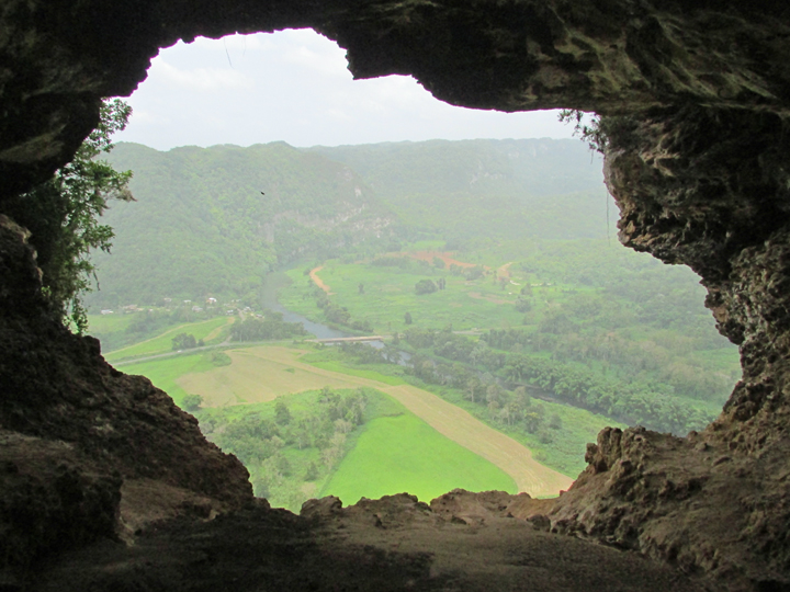
First stop was La Cueva Ventana (the Window Cave) up in the center of the island. It's a very popular attraction that has become more "civilized" in recent years. It's on private property and the owners started charging admission a couple of years ago. Now there are (informed, educated) guides. Visitors wear hard hats and are given flashlights. Those changes are actually are good things. They've reduced the trash and the vandalism to this beautiful, historically important site.


Along the trail from the parking lot to the cave entrance, the guide talks about the geology, biology and history of the area. For example, this tree is known at the "Guardian" because it "protects" an entrance to one of the caverns.


At the cave entrance the group climbs a steep path down into the darkness. From the entrance to the Window (la ventana) is a 300' walk (it truly doesn't seem that long). Tat the end is a large cavern room with the window at the end.  From the lip of the window the the valley floor below is a nearly 800 foot drop. There are so many pictures of the valley through the window on Facebook it has become one of the iconic images of Puerto Rico.

The center of the island is like Swiss cheese, riddled with holes and caves. There are more that 2,000 known caves, only about 200 of which have been fully explored and mapped. (A friend of ours spends several weeks each year mapping caves on Mona Island, a tiny island in the Mona Passage between Puerto Rico and the Domincan Republic. He told me there are 225 caves on Mona. They've mapped and explored 210 of them. He said they have at least three more years of work on the island. And those are just caves above water. There are more below.) Many of these caves are important historic and archeological sites. Some, including La Cueva Ventana, have pictographs and art left by indigenous peoples.


Unfortunately, many of the caves also include "art" left more recently.

Part 2 of the Adventure coming later.

Tuesday, June 16, 2015

Day one of my birhtday week

Someone asked me if this was a "milestone" birthday. At this point in my life, they're all milestones!

Here in Puerto Rico we don't just celebrate birthDAYS. We celebrate birth-WEEKS, sometimes months, maybe "Hey, I have a birthday this year!"

My birth-week started with a surprise celebration last night at Ola Lola's. Elaine flat out told me she wasn't planning anything. But wait! I've been joking that this year a become a Beatles' song - I turn 64.

Many of you know Elaine's tradition of rewriting songs for special occasions. She just couldn't
get "When I'm Sixty-four" out of her head. And so, I present you with my birthday song:


It was an amazing wonderful surprise! The whole bar full of people sang along.


Thank you Susie Tobin for the photos. I was busy!


Thursday, May 14, 2015

Would you like fries with that?


This is post that really should have been written a couple of months ago. Elaine retired from the kitchen in February. Our good friends Danny and Maria took over running the Ola Lola's kitchen. After eight years of totally avoiding deep fryers - staples of many restaurant kitchens here - we gave in to Danny's request to put one in.

So far we're very happy with it! Our house doesn't smell like oil which was one of our fears. So far we haven't had an oil fire (another fear) so our house is still here to not smell like oil.

And for the first time, we offer FRIES with our burgers. Danny has also added fish tacos and fish sandwiches to the menu.

Danny and Maria are no strangers to the Isabela/Aguadilla restaurant scene. Danny worked for several years with one of the best chefs in the area before they opened their own restaurant, Nomadas. Since he closed Nomadas, Danny has worked and/or been in charge of several restaurant kitchens. 

And Elaine in "retirement?" Well, not really. She's working her tail off, just at other things. One of the biggest is a non-profit she started called Calorcito pal Corazon (Warmth for the Heart). More about that soon.

Wednesday, May 13, 2015

Diving the Rincon Wall


Rincon, about 45 minutes south of us, is best known for it's surf. Turns out there's some pretty good diving there too.

There is a "wall" dive just off-shore on the south side of Rincon, Yesterday we made the trek to Ricon to dive the wall. 

We planned to go at the same spot we did last time. It's quite a kick-out over some pretty uninteresting sand to get to the reef and the top of the wall. But - somebody forgot to take weights. (That's another fairly unintersting story.)  So we jumped back in the truck and headed for the local dive shop to borrow weights.

We talked to our friend Brenda at Rincon Diving and Snorkeling and she suggested we enter the water a bit further down  Brenda showed on a map: the top of the wall is much closer to shore at the site farther south. A shorter swim-out (and thus back) meant more time on the wall!

The Rincon Wall is interesting. At the point we entered, the top of the wall is about 35 feet deep. In contrast, the top of the wall at the "Blue House," the entry point further north, is at about 65 feet. The "big" wall way south off La Parguera starts at about 75 feet.

Why does this matter? In scuba diving depth limits your time under water because of both air consumption (you use more air from your tank when you go deeper) and nitrogen saturation (your body absorbs more nitrogen at greater depths). Getting the full effect of diving on a wall at shallower depths means you can safely enjoy it longer. The Rincon Wall extends to depths of over 120 feet but you don't have to dive anywhere near that deep to enjoy it. You can see more photos from this dive on our Flickr page.

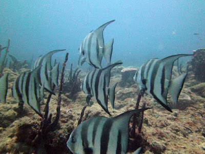
The reef along the wall is truly amazing. Hard corals, soft corals (like seafans), tube sponges (above) and barrel sponges provide food and hiding places for many many species of fish.

This is only the second time we've been there. It's not as easy as our local dives which are at most 15 minutes drive from here. But when the conditions are right, it's a great alternative. You can bet this won't be the last time we dive there.